Cyclone Fina is forecasted to reach category 4 tomorrow after, although it’s expected to remain offshore.
Radar and satellite imagery shows Fina on the south coast of Melville Island as a compact yet strong system, the Bureau of Meteorology said tonight.
The forecast path shows the most likely direction and strength. The cyclone centre may take another track within the grey zone.
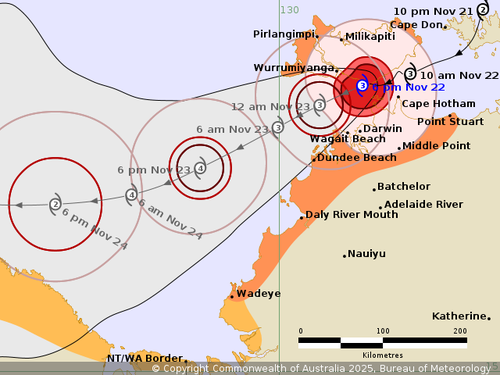
After passing Darwin, the cyclone is set to maintain severe tropical cyclone intensity tomorrow and still on Monday as it moves through the Timor Sea’s south.
Cyclone Fina is forecast to start weakening on Monday or Tuesday near the Kimberley coast.
“As we go through this evening, the winds will pick up noticeably and it will be a big system and a long night,” the BoM’s Shenagh Gamble said today.

