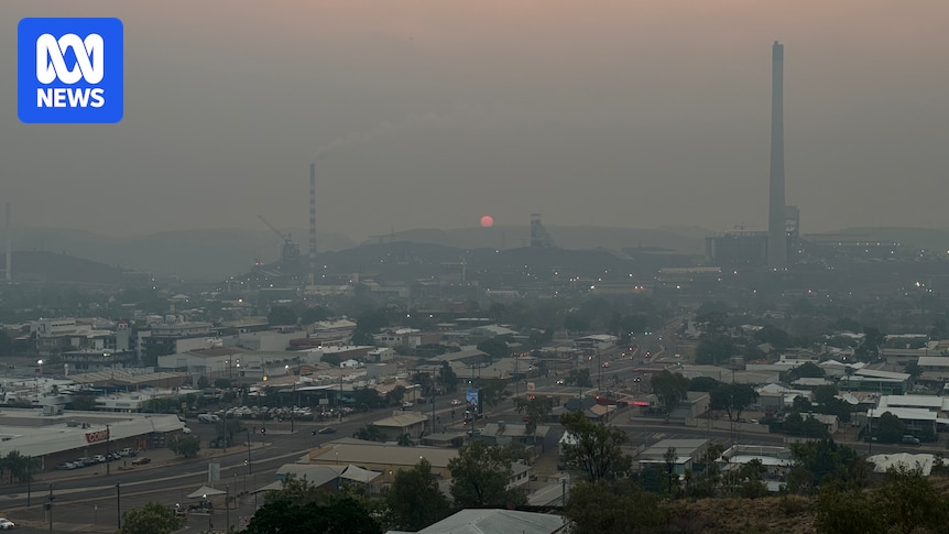
The bright orange sunset that usually graces red dirt plains looked different as it set over outback Queensland this week.
Fighting against a blanket of smoke following nearly two months of bushfires, residents of Mount Isa scrambled to capture a glimpse of the orange globe before it disappeared into the smog.
For a period on Tuesday evening, according to the Air Quality Index, the mining city held the title for the most polluted city in the world.
The city has been inundated with smoke, which has led to an uptick in respiratory-related hospital presentations. (ABC North West Qld: Emily Dobson)
The Mount Isa Hospital has seen an increased average of seven people presenting daily with exacerbated conditions like asthma, owing to current weather conditions.
Lyn White, whose property, Melaleuca, is impacted by a fire burning nearby, said she had been shocked to see flames everywhere when she was driving along the road.
“It jumped the road right there in front of me and I thought we were done,” she said.
“Like the hand of God there was a Rural Fire brigade guy doing a patrol, he was able to put out the fire jumping the road and call for more crews.”
Loading…
Scorching spring
It is not officially summer, but already an area stretching the same distance as Brisbane to the Sunshine Coast has burnt in the outback.
With the mercury tipped to reach 43 degrees Celsius in parts of the region, firefighters are on stand-by for worsening conditions.
“With that increased heat, obviously our concerns increase with the potential for fire,” Superintendent for Rural Fire Service Queensland Shane Hopton said.
Water-bombing aircraft have been called in to relieve crews on the ground.
Water-bombing aircraft assisted with fires in Mount Isa for the first time 12 months ago. (Supplied: Mount Isa Aviation Photography)
“It makes a significant impact, even as an observation platform to provide intel,” he said.
“We can get a grasp of the size of the fire, if any water points are able to be located, if there are any properties or structures under threat, we can capture all that from the sky.”
Life on the burnt-out land
Landholders have been stretched thin since early September, working to protect their property from the path of destruction.
In the first 16 days of spring, Queensland firefighters responded to more than 40 incidents in Mount Isa alone.
Recent fires burning to the south of Mount Isa have led to a blanket of smoke over the city. (Supplied: Marco Bracchi)
From September 1 to October 21, across the northern region the number of landscape fires attended by firefighters jumped to 306.
One blaze that began deep in the north west has traversed more than 100,000 hectares, the same size as a small European country.
The blaze began south of Mount Isa at Mount Guide Station and wrapped behind the mining city north-west 40 kilometres to Pilpah Range.
Fires south of Mount Isa, captured by a researcher during the Eastern Waterbird Survey, earlier this month. (Supplied: Richard Kingsford)
Deep in the Gulf country, a bigger, second blaze is coming to its end.
At this time of year, a lightning strike in the bush is like striking a match in a tinderbox.
What began with an electrical storm at Riversleigh Station about 10 days ago spread north to Adels Grove and Lawn Hill Station at a total diameter of around 50km.
Noemie Soulet manages a camping park near Adels Grove, 320km north of Mount Isa, and said she was exhausted after spending days on the front line.
“It was scary. We were firefighting from the early morning into the evening. We couldn’t sleep at night; I was too concerned and too stressed,” Ms Soulet said.
A heat map shows major blazes burning in the north west. (Supplied: Northern Australia Fire Information)
“It was raining ashes everywhere; animals were all running away. I saw a mob of kangaroos coming from the flames,” she said.
The same region was swamped with fire 10 months ago, but Ms Soulet said the most recent blaze was much worse.
“I’ve never seen anything like this before,” she said.
“It was so much bigger than in January. That fire came from one side, but we were totally in the middle of this fire so it was much scarier.
“It came close to Century Mine, they’ve been working hard because otherwise we would have been smashed much more.”
The fire has now moved on from the Adels Grove area. (Supplied: Noemie Soulet)
Nearby mine impacted
South Africa’s largest gold miner has suspended operations at its north-west Queensland zinc mine site.
Sibanye-Stillwater head of investor relations James Wellsted said that despite their best efforts Century operations had been impacted.
“It managed to leap the firebreaks we had already in place, [but] we were able to prevent damage to the major infrastructure like the camp,” he said.
“We have an extensive network of polyurethane pipes that transport materials and we saw damage to that, which will have to be replaced.
“We can only expect that to be done about mid-November.”
