Unusual Tasman Sea weather giving late burst of warmth before winter


Abnormally warm temperatures in the Tasman Sea have given Sydney its warmest start to May in eight years.
Pools of water in the sea are between two and four degrees warmer than average from this time of year, and are leading to changed weather in Sydney just a week after a cold snap hit.
“Daytime maximum temperatures in Sydney have been running around two to four degrees above average since late last week,” Weatherzone’s Ben Domensino said.
Warmer sea temperatures off the Tasman Sea are continuing to have surprise impacts on Sydney's weather.
Warmer sea temperatures off the Tasman Sea are continuing to have surprise impacts on Sydney’s weather. (Weatherzone)

“The running average temperature during the first 13 days of this month have been more than three degrees above average.”

The warmer waters are being caused by the East Australian Current, which is bringing warmer waters from the Coral Sea southwards towards New South Wales, Victoria and Tasmania.

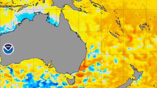
“Water temperatures in much of the western Tasman Sea are currently in the top 10 per cent of historical records for this time of year,” Domensino added.

Sydney will have a warm but wet next few days. (Supplied)

He said it was not the only change to face Sydney, with onshore winds carrying rain from the Tasman Sea along the coast and mountain ranges.

Sydney is facing rain for the next week, with the peak being seen on Tuesday where up to 10mm could fall.

Despite this, temperatures will remain fairly warm, with a top of 24 degrees on Sunday.

“Sydney will continue to see daytime maximum temperatures around 22 to 24 degrees, hovering a few degrees above the May average of 19.6 degrees,” Domensino said. 

NEVER MISS A STORY: Get your breaking news and exclusive stories first by following us across all platforms.


Source link

spot_imgspot_img

Subscribe

Related articles

spot_imgspot_img

LEAVE A REPLY

Please enter your comment!
Please enter your name here

eight − six =